CUYAMA OAKS XP
NEW CUYAMA, CALIFORNIA
March 27-28-29, 2026
I spoke with Jon Jones after the Gifford Fire and he is confident the ride will go on as usual. The fire was stopped at the Kidd Ranch, so everything east of that is fine. The main damage was to the structures and the chaparral. Jon reports that some old roads were opened back up which will provide us with some new options. The wildflowers and grass should be back to normal by ride time next year.
We offer AERC sanctioned endurance and LD distances as well as XP Club Rides
The distances are subject to change due to weather and land owner restrictions 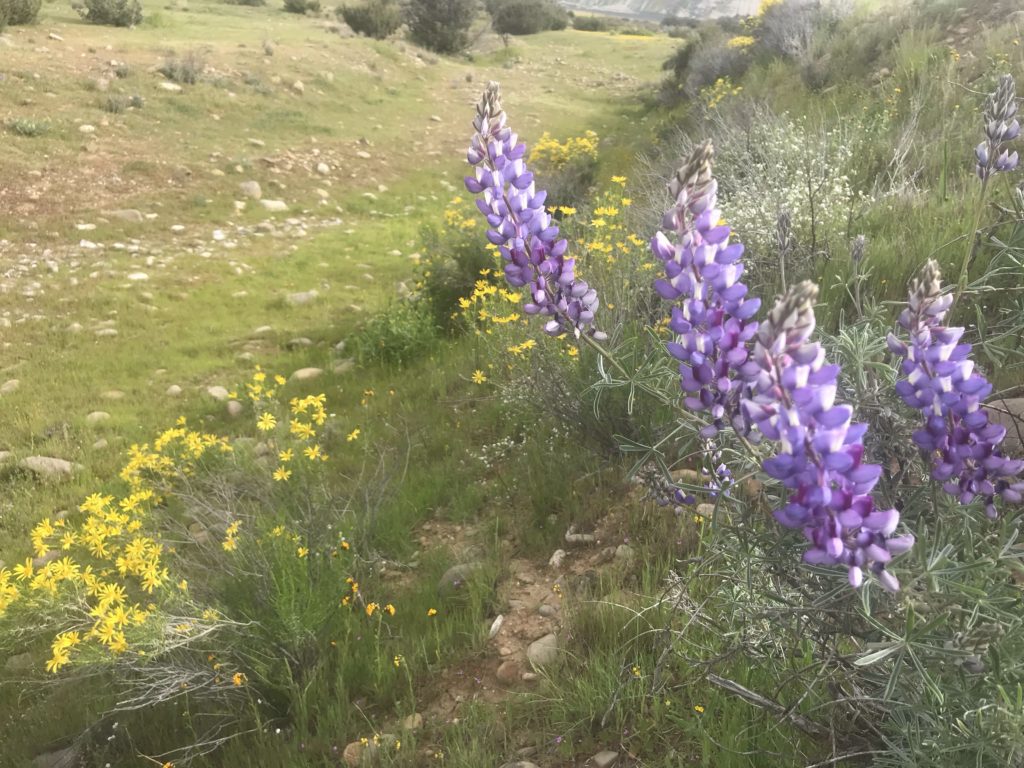


NEW CUYAMA, CALIFORNIA
CUYAMA INFORMATION
This is the 23rd year of our popular ride in New Cuyama, located in the grasslands and oak covered foothills between Bakersfield and Santa Maria. When the wildflowers and spring grasses are blooming its one of the most beautiful places on earth. The ride was actually started by Jim Mitchell who gave us unlimited support and use of his ranch in Schoolhouse Canyon. After more than a decade the original land grant property between the Mitchell Ranch and the highway was sold to Harvard University who converted it to a vineyard. When that happened it looked like we would lose access to the foothill trails. Fortunately, Jon and Mari Jones, ranchers on Cottonwood Road, allowed us to camp on their property in Cottonwood Canyon and that allowed us to keep the ride going. The Jones Ranch is a lovely place to camp but when it rains it is impossible to camp there. When that happens we move the camp next door to the Hassett Thomson Ranch in wet years. We always hope to be back on the Jones Ranch where we can camp under the oak trees once again, but its the Hazlet Family that ensures us a place to camp regardless of the weather. This is a very special event as it requires the permission of so many different land owners in an area that few wish to share their property with others. We have been fortunate to have so many people supporting us in Cuyama Valley. There are private roads and trails connecting the various properties, so we’re able to use all the scenic loops near the mountains that we have in the past. Once again, Jon has checked with neighbors to the west for access to lands we haven’t been able to use in the past. Jon remains our contact for keeping everything in place for the ride. Last fall and this year Richard spent much of the winter at the Jones Ranch and is responsible for keeping the trails open, which is no small task. Historical information of the area is available on our expanded Cuyama information page under 2026 XP Rides and Dates.
Address for Health Certificates: Jones Ranch, 2401 Cottonwood Canyon Road, New Cuyama, CA 93254 No health certificates are required for horses originating in California.
TRAIL: Most of the ride takes place on private lands that trace back to the old Spanish Land Grants. The trail is more difficult than most XP Rides and ranges from a crude single track to dirt roads. There will be wire gates to open and close as we pass through private cattle country. The trail has some rocky portions that some feel necessitate the use of hoof protection. The elevation at camp is 2600 feet. The area is home to mountain lion, bear, coyotes, and an occasional Frozen Duck. The trails wind through the same rolling pastures that have supported cattle since the days of the California Vaqueros.
AWARDS: Participation awards will be given to all participants. Horse and rider teams that complete all three days are eligible for an XP Vest awards.
CUYAMA HISTORY: Local Information The Cuyama Valley is best known for its oil strike of the 40’s and 50’s. Richfield Oil Company was instrumental in the establishment of the town site as it is today. Yet Cuyama’s history dates much farther back and is significantly woven into the fabric of California history as a state and a territory. There are many pronunciations of the name “Cuyama”. Some of the more common mispronunciations are “Cay-u-ma”, “Kee-ah-ma, and “Koo-yah-mah”. The Duck’s favorite is “Nuke-yor-mama”. The proper pronunciation is “Kwee-ah-ma”, suspected to be Chumash for Valley of the Clams. There are, in fact, considerable deposits of fossilized marine sediment containing clam shells in and around the valley. The name can be documented on paper as far back as 1843 when the name Arroyo Llamado de Cuyam is mentioned and again in 1846 when the name Cuyama was given to two land grants. Some suggest it has its origins in the word Kuyam, meaning to rest, repose, sit and wait. Extensive deposits of fossilized marine sediment are found in the Cuyama Valley. These beds contain the fossilized remains of Ostrea titan, the huge oyster, Argo pecten, an early scallop, and Astrodapsis cuyamesis, an early sand dollar. The Astrodopsis cuyamesis takes its species name from the Cuyama Valley as this is the only place to date that fossilized remains can be found.
In addition to early architecture, Cuyama Valley has many points of pre-California and prehistoric interest as well. The Chumash Indians were some of the earliest documented inhabitants of the valley. Extensive anthropological study of the valley estimates their population to have been as high as 1000 and 30,000 in their entire range. The Chumash were centrally based hunters and gatherers that traveled seasonally to resources, such as pinion nuts and antelope, and did not take part in agriculture. The Chumash inhabited the area for 13,000 years. The evidence of their presence appears as cave and rock paintings scattered throughout the Cuyama Valley and Carrizo Plains as well as stone artifacts commonly found in this area. The natural erosion process and vandalism have taken their toll and many of these sites are now under the auspices of the Nature Conservancy and the BLM. Guided tours are available locally for their viewing. Many of the Chumash village site artifacts collected from the Cuyama Valley are on display at the Natural History Museum in Santa Barbara. As you ride to the top of the mountain on the last day, you will be able to see the mountain ranges north of Santa Barbara where the mission was located. The Chumash Indians revolted many times under the repressive mission system and escaped from their Spanish captors and made it to this area. Their recapture in the San Joaquin Valley and arduous trip back thru Cuyama to the mission is a little known California version of the “trail of tears”. The old trails to the east of Hog Pen Springs were the main route back to the mission.
In 1841, the Bartelson Party of wagon trains headed west from Missouri, using the route many of us traversed on the summer XP 2001. Among them was eighteen year old Nancy Kelsey and her husband Benjamin. They began their journey with sixty nine men, women and children. On November 4, 1841, six months after beginning their journey, Benjamin Kelsey and John Bidwell led the remaining twenty-four emigrants across the Sierra Nevada Range into California. During the Bear Flag Revolt of 1846, Nancy Kelsey was chosen to create the flag for the California Republic. With designs of William Todd, a nephew of Abraham Lincoln, she fashioned the flag from a piece of unbleached muslin and a strip of red fabric from her petticoat. Her design is still flown today as the state flag of California. Throughout the years, Nancy and her husband traveled extensively. When Benjamin died in Los Angeles in 1888, Nancy, remembering the Cuyama Valley as one of her favorite places, applied for and received a government homestead of 160 acres in what is now Kelsey Canyon. She built a homestead cabin and began raising poultry. At regular intervals, she traveled by buckboard to Santa Maria to market fryers and setting hens. When Nancy neared death she was cared for by the family living nearby in Cottonwood Canyon. After her death a “real” coffin was brought from Santa Maria by buckboard as per her request and she was buried by the homestead she died at. Bonnie Goller now lives on that homestead and has graciously allowed us to pass through her private property on the ride. We will pass by the Nancy Kelsey grave site on the last day just before we enter Bates Canyon, on the climb to the top of the Sierra Madres.
The Mexican land grants in the valley are relatively recent and date to the period just before California was taken over by the United States. After California was admitted to the Union, many smaller homesteads were granted in the area, including the one that you are camped on. The base camp is located in Schoolhouse Canyon, named for the first school in Cuyama Valley. That one room school was located in the north end of the camp pasture near the yellow gate. Old stone ruins remain along the fence line west of the gate. A second school was built in the 1930’s and was later used as the ranch house for the Spade ranch. Most of the later homesteads are in the brush covered foothills, while the old Mexican land grant was located in the lower country where the grazing would have been better. The town of New Cuyama is probably most famous, in current times for the Buckhorn Bar and restaurant. Established in 1953 by Richfield Oil, to service the new town and to provide a meeting and recreation place for its employees, it has come to be known in modern times for its great food and friendly atmosphere. The banquet room features “ Lamar’s Cabin”, named for Cuyama’s longest resident, Lamar Johnson. A mini museum, Lamars Cabin should be seen by anyone interested in the colorful history of Cuyama.
In the two years following the initial oil strike, Cuyama’s oil fields boomed into fifth place among California’s oil areas in average daily production. Today, Hallador production is still involved in gas and oil production on the same location and is a major employer in the valley. The original land grant is now known as the Russell Ranch and runs from the area north of New Cuyama down to Cottonwood Canyon. Most of the open lands in the lower elevations are part of the ranch. It has been divided into large pastures so that the cattle can be moved from one pasture to another to make the best use of the feed. In most years, the cattle will be able to remain here in the valley on a permanent basis, but modern transportation now allows the flexibility to move them to summer pastures and some distant location during drought years, such as the present. The wild pigs are a fairly recent addition and have moved into the Schoolhouse and Deadman Canyon areas in the last few years. The pigs are not a native species but are descendants of domestic pigs, Spanish escapees and Russian pigs imported for hunting. The pigs can often be seen in the brushy areas along the river and have been seen recently near the windmill just north of the yellow gate. Much of the information in this paper was plagiarized from the menu at the Buckhorn Cafe in New Cuyama. The Buckhorn Cafe, bar and hotel reopens and closes on a regular basis, so we no longer try to keep up with the changes.
Think of this as an alternate equine event that can be an excellent place to start young horses or enjoy some relaxed rides on an old campaigner.
Phone 907 209 8881 or e-mail duck@xprides.com
Ride Fees
The 2024 entry fees FOR CUYAMA ONLY are as follows:
LD and Endurance Entry Fees, per day are $145.00 / PayPal $150.80
Juniors, Intro riders and XP club riders are $120 / PayPal $124.80
Riders who are not CURRENT members of AERC riding an AERC LD or Endurance ride pay an additional $20.00 non-member fee per day. $165.00 / PayPal 6.60
Riders who enter within 4 days of a ride add $15.00 post entry fee / PayPal 15.60
Riders who ride all three days will receive a $10.00 discount per day.
To save the Paypal fee you can mail a check and we will accept your word in an email that you have actually mailed the check. We consider a person’s word to be their bond. It’s like the old west and we have a long memory so it definitely pays to be honest. Checks can be made to Ann Nicholson, 19898 Road V, Lewis, CO 81327.
We do not cash checks or withdraw funds from out PayPal account until the ride is over.
- If you plan to ride three days send $405.00 / $421 PayPal
- If you intend to ride two days, send $290.00 / $301.60 PayPal and indicate which two days you intend to ride on the check.
- If you intend to ride one day, send $145.00 / PayPal $150.80 and indicate which day you intend to ride as well as sending us an email.
- If you are not a current member of AERC, add $20.00 for each day you intend to ride an AERC LD or 50, for the AERC day member fee. If you are not interested in AERC points and are riding the intro/club ride, this will not apply to you. You are welcome to ride the full distance for club mileage as long as you don’t interfere with the AERC competitors.
- After you send your check or PayPal please send an email with your decision.
NOTICE CHANGES REGARDING MEALS MADE ON MARCH 22ND
- Annie and her volunteers will continue to offer sandwiches, snacks and candy at the lunch stops. Annie will offer a Barbecue with cheeseburgers, baked beans and a variety of salads on Friday evening and a Mexican Fiesta by Juan on Saturday night. There will be vegetarian options both nights. All meals are prepared by Annie and her volunteers under remote camp conditions, just like the old days. Eat at your own risk.
Add a $30.00 donation for dinners on both nights. Don’t plan to eat unless you make reservations!! Annie HAS to know by Monday the 21st at noon. Make these reservations by a direct and separate email to Annie@xprides.com.
REFUND POLICY
Cancellation Refunds: Ride entry withdrawal requests received via email on/before 1800 hours on March 21st will receive a full refund. There will be an administrative fee for refunds between the 21st and 1800 hours, 25th. No refund for withdrawals after March 21st, or for no shows.